This article is part 4 of a series on what’s involved when navigating across the English Channel and covers shaping your course at the end of the passage.
- Determine your departure time (which often depends on when you want to arrive or when you must arrive by)
- Estimating the net tidal set and drift you’ll experience during the crossing
- Determine your course to steer by applying tide, variation, deviation and leeway
- Final course shaping a couple of hours before arrival
In the previous article, we estimated our course to steer for the main passage. The final step is to correct the inevitable errors and shape our course into the harbour.
Final course shaping
This is far more important when sailing to Cherbourg than to the Isle of Wight since the tidal streams across the peninsula are so strong – they can run at 3 knots. If you arrive the wrong side of Cherbourg then this can make the difference between dinner at a bistro or dinner onboard.
It is therefore essential to monitor your position on a chart to check you’re making the course you expected – plot your position on the chart rather than just recording a log entry. Read what happened on my first crossing when we omitted to do this (I learnt this the hard way and have never repeated it since).
Having set your destination for 1-2nm up tide of the Cherbourg entrance for your main course to steer, at around 2 hours from destination work through a new one.
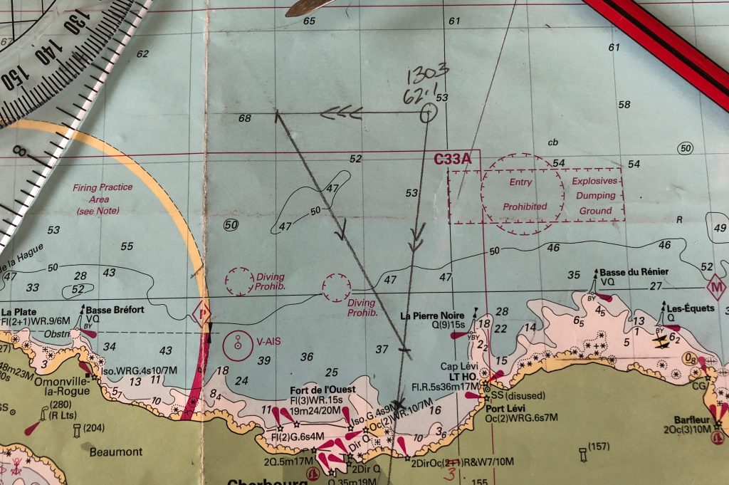
In this example, we’re around 10 miles off Cherbourg and have plotted our fix at 1303.
- We know that this afternoon the tide runs strong east to west at Cherbourg so we set our destination 1½ miles up tide (east)
- We draw a ground track line (2 arrows) from our fix to and beyond our waypoint
- Consulting Reeve-Fowkes Yachtsman’s Manual of Tides we see that at HW+5 and HW+6 the tide runs 2.8 knots for the next 2 hours
- We plot a tidal (3 arrows) line 5.6nm west from our fix
- We now intersect our ground track with a 10nm line (2 hours at 5 knots) from the end of the tidal vector – 1 arrow
- We measure the angle of this line as 153T – our true course and adjust for variation, deviation and leeway before passing our CTS to the helm
- Incidentally, the length of the line from our fix to the intersect is 8.8nm and tells us our speed over the ground is 4.4knots (8.2nm ÷ 2 hours). If you think about this, it makes sense since a good deal of our effort is punching that tide. We should be there in around 2½ hours
Use your chartplotter to manage cross track error
Now is also the time to set your waypoint on the chart plotter and switch to the cross track error rolling road.
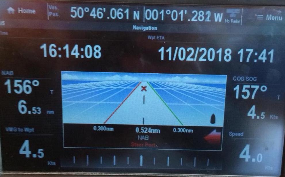
If your calculations are right then the bearing to waypoint (BTW) and course over the ground (COG) should be the same. If not, then have your helm adjust course until they match, and note the new compass course in the log in case you need to work up an EP later.
As you get closer and closer to the waypoint you can change the destination to the harbour entrance paying close attention to BTW/COG.
Summary of recommended resources
You’re going to need access to one or more of these resources to help in your planning. I’ve cover each of these in the series so have a read first before buying.
Fantastic, Thank You!
Excellent account and very well placed graphics and resource URLs.