This article is part 3 of a series on what’s involved when navigating across the English Channel and covers plotting a course to steer.
- Determine your departure time (which often depends on when you want to arrive or when you must arrive by)
- Estimating the net tidal set and drift you’ll experience during the crossing
- Determine your course to steer by applying tide, variation, deviation and leeway
- Final course shaping a couple of hours before arrival
In the previous article, we estimated the effect of the tides during our crossing using a Tidal Stream atlas. The next step is to apply this to determine our course to steer (CTS).
Plot your Course to Steer
You can probably guess that 4.3nm of tidal drift east over a 65nm southerly passage isn’t going to make a huge difference to the actual course. Every crossing is different however, especially if you’re making way significantly faster or slower than a typical two full tide span (12 hours) which largely cancel each other.
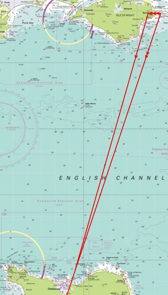
Here I have plotted :-
- a ground track (2 arrows) starting from Bembridge ECM to and beyond a waypoint 1½ miles up tide of our destination. Read in final course shaping about why this waypoint should be up tide (especially in cases of strong tides east or west on arrival)
- a 4.3nm tidal vector (3 arrows) west from Bembridge
- a 65nm (13 hours at 5 kts) water track (1 arrow) from the end of the tidal vector intersecting the ground track
Measuring our water track with a plotter shows 202T and we need to adjust for variation, deviation & leeway.
Adjust for magnetic variation and compass deviation
Local variation is 2°W so we will add this to the true heading (“west is best”). The compass card for 204 on our yacht shows 1°W deviation at so we add this too (“west is best”) to find a course to steer of 205C.
Adjust for leeway
The winds forecast were reasonably light and from the beam so there won’t be much leeway, say 3° (if we were close hauled it might be as much as 10°, on a broad reach or run almost zero; much worse upwind in a heavy sea). Since the wind is coming from the east the leeway will push us west so we need to subtract 3° to compensate and tell the helm to steer 202.
Don’t be tempted to ignore all these small adjustments. They added up here to 6°, so considering that 1° every 60 miles will result in 1 mile of error, we’d be 6 miles out around the time we start to shape our final approach. And that’s over and above any helming error.
The crew having helmed for the best part of the crossing we need to shape our final course since it’s very unlikely that we’ve ended up exactly on target.
The next article describes the final step – course shaping at the end of our passage.
If the wind is easterly wouldn’t you deduct 3 degrees leeway from your course?
You’re right! There’s some inconsistency in the article as to travelling to/from Cherbourg. I’ve updated it now and need to make the article more consistent. Thanks for the spot